ملف:Erzurum districts.png
حجم البروفه دى: 776 × 600 بكسل. الأبعاد التانيه: 311 × 240 بكسل | 621 × 480 بكسل | 994 × 768 بكسل | 1,056 × 816 بكسل.
الصوره الاصليه (1,056 × 816 بكسل حجم الفايل: 38 كيلوبايت، نوع MIME: image/png)
الخلاصة
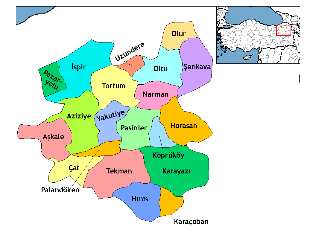
| وصف | Map of the districts of Erzurum province in Turkey. Created by Rarelibra 19:53, 1 December 2006 (UTC) for public domain use, using MapInfo Professional v8.5 and various mapping resources. Edited by One Homo Sapiens Corrected text where İ,Ş,ı,ğ,or ş occurs in name. Source: [statoids-com]. Increased font size and enhanced color differences among adjacent districts. |
| تاريخ | 1 ديسمبر 2006 (تاريخ الرفع الأصيل) |
| مصدر | لم يتم توفير مصدر قابل للقراءة، العمل الشخصي مفترض (بناء على مطالبات حقوق الطبع والنشر). |
| مؤلف | لم يتم توفير مؤلف قابل للقراءة; يُفترَض Rarelibra (استنادا إلى مطالبات حقوق الطبع والنشر). |
الترخيص
| أنا، مالِك حقوق تأليف ونشر هذا العمل، أجعله في النِّطاق العامِّ، يسري هذا في أرجاء العالم كلِّه. في بعض البلدان، قد يكون هذا التَّرخيص غيرَ مُمكنٍ قانونيَّاً، في هذه الحالة: أمنح الجميع حق استخدام هذا العمل لأي غرض دون أي شرط ما لم يفرض القانون شروطًا إضافية. |
تاريخ الفايل
اضغط على الساعه/التاريخ علشان تشوف الفايل زى ما كان فى الوقت ده.
| الساعه / التاريخ | صورة صغيرة | ابعاد | يوزر | تعليق | |
|---|---|---|---|---|---|
| دلوقتي | 02:52، 18 ابريل 2009 | | 1,056 × 816 (38 كيلوبايت) | One Homo Sapiens | Added Aziziye, Palandöken and Yakutiye, that replaced Erzurum merkezi and Ilıca districts. Source: << www.erzurum.gov.tr >> |
| 22:20، 28 ديسمبر 2008 |  | 1,056 × 816 (41 كيلوبايت) | One Homo Sapiens | Corrected text where İ,Ş,ı,ğ,or ş occurs in name. Source: [statoids-com]. Increased font size and enhanced color differences among adjacent districts. | |
| 19:53، 1 ديسمبر 2006 |  | 1,056 × 816 (35 كيلوبايت) | Rarelibra | Map of the districts of Erzurum province in Turkey. Created by ~~~~ for public domain use, using MapInfo Professional v8.5 and various mapping resources. |
استخدام الفايل
استخدام الملف العام
الويكيات التانيه دى بتستخدم الفايل ده:
- الاستخدام ف ar.wikipedia.org
- الاستخدام ف ast.wikipedia.org
- الاستخدام ف azb.wikipedia.org
- الاستخدام ف ba.wikipedia.org
- الاستخدام ف bs.wikipedia.org
- الاستخدام ف ca.wikipedia.org
- الاستخدام ف cs.wikipedia.org
- الاستخدام ف de.wikipedia.org
- الاستخدام ف diq.wikipedia.org
- الاستخدام ف en.wikipedia.org
اعرض استخدام عام اكتر للملف ده.
Text is available under the CC BY-SA 4.0 license; additional terms may apply.
Images, videos and audio are available under their respective licenses.
Cover photo is available under {{::mainImage.info.license.name || 'Unknown'}} license.
Cover photo is available under {{::mainImage.info.license.name || 'Unknown'}} license.
Credit:
(see original file).
