يوكسكوفا
| يوكسكوفا (غيفر) | |
|---|---|
 |
|
 |
|
| الإحداثيات | |
| تقسيم إداري | |
| البلد | |
| المحافظة | حكاري |
| الحكومة | |
| عمدة | ركن يتيشكين (حزب السلام والديمقراطية) |
| قائم مقام | عزير عزيز أزيرن |
| خصائص جغرافية [1] | |
| مدينة | 2385 كيلومتر مربع |
| القضاء | 2٬371٫85 كم2 (915٫78 ميل2) |
| ارتفاع | 1٬950 م (6٬400 قدم) |
| عدد السكان (2012)[2] | |
| عدد السكان (2012)[2] | 119760 (2018) |
| الكثافة السكانية | 50.21 نسمة/كم2 |
| حضر | 68230 |
| ريف | 47650 (2015) 45269 (2016) 47012 (2021) |
| القضاء | 115٬966 |
| كثافة القضاء | 49/كم2 (130/ميل2) |
| معلومات أخرى | |
| منطقة زمنية | ت ع م+03:00 |
| رمز البريد | 30300 |
| رمز جيونيمز | 7733232 |
| الموقع الرسمي | www |
| تعديل مصدري - تعديل | |
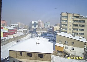
يوكسكوفا هي مدينة يسكنها أكراد وعرفت سابقاً باسم غيفر، وهو قضاء في محافظة حكاري التركية الواقعة على الحدود مع إيران.[3]
المناخ
[عدل]يظهر الجدول التالي التغييرات المناخية على مدار السنة ليوكسكوفا:
| البيانات المناخية لـيوكسكوفا | |||||||||||||
|---|---|---|---|---|---|---|---|---|---|---|---|---|---|
| الشهر | يناير | فبراير | مارس | أبريل | مايو | يونيو | يوليو | أغسطس | سبتمبر | أكتوبر | نوفمبر | ديسمبر | المعدل السنوي |
| متوسط درجة الحرارة الكبرى °م (°ف) | −6.4 (20.5) |
−4.0 (24.8) |
2.7 (36.9) |
10.3 (50.5) |
17.6 (63.7) |
22.8 (73.0) |
26.7 (80.1) |
26.8 (80.2) |
23.2 (73.8) |
16.3 (61.3) |
7.7 (45.9) |
−3.3 (26.1) |
11.7 (53.1) |
| المتوسط اليومي °م (°ف) | −9.0 (15.8) |
−7.3 (18.9) |
−0.7 (30.7) |
6.0 (42.8) |
12.1 (53.8) |
16.5 (61.7) |
20.3 (68.5) |
20.2 (68.4) |
16.4 (61.5) |
10.5 (50.9) |
3.3 (37.9) |
−5.5 (22.1) |
6.9 (44.4) |
| متوسط درجة الحرارة الصغرى °م (°ف) | −11.5 (11.3) |
−10.6 (12.9) |
−4.0 (24.8) |
1.8 (35.2) |
6.6 (43.9) |
10.3 (50.5) |
13.6 (56.5) |
13.9 (57.0) |
9.6 (49.3) |
4.7 (40.5) |
−1.0 (30.2) |
−7.7 (18.1) |
2.1 (35.9) |
| الهطول مم (إنش) | 71 (2.8) |
90 (3.5) |
104 (4.1) |
106 (4.2) |
58 (2.3) |
18 (0.7) |
6 (0.2) |
5 (0.2) |
6 (0.2) |
50 (2.0) |
76 (3.0) |
80 (3.1) |
670 (26.3) |
| المصدر: Climate-Data.org[4] | |||||||||||||
مراجع
[عدل]- ^ "Area of regions (including lakes), km²". Regional Statistics Database. Turkish Statistical Institute. 2002. اطلع عليه بتاريخ 2013-03-05.
- ^ "Population of province/district centers and towns/villages by districts - 2012". Address Based Population Registration System (ABPRS) Database. Turkish Statistical Institute. اطلع عليه بتاريخ 2013-02-27.
- ^ "معلومات عن يوكسكوفا على موقع geonames.org". geonames.org. مؤرشف من الأصل في 2019-12-16.
- ^ "Climate:Yüksekova". Climate-Data.org. مؤرشف من الأصل في 2018-06-17. اطلع عليه بتاريخ 2014-04-11.
| في كومنز صور وملفات عن: يوكسكوفا |
Text is available under the CC BY-SA 4.0 license; additional terms may apply.
Images, videos and audio are available under their respective licenses.
