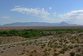
موابا فالي
| موابا فالي | |
|---|---|
 |
|
 |
|
 |
|
| الإحداثيات | 36°34′28″N 114°27′29″W / 36.574444444444°N 114.45805555556°W [1] |
| تقسيم إداري | |
| البلد | |
| التقسيم الأعلى | نيفادا |
| خصائص جغرافية | |
| المساحة | 113.176917 كيلومتر مربع 113.176914 كيلومتر مربع (1 أبريل 2010) |
| ارتفاع | 407 متر |
| عدد السكان | |
| عدد السكان | 6289 (1 أبريل 2020)[3] |
| عدد الأسر | 2373 (31 ديسمبر 2020)[4] |
| معلومات أخرى | |
| 89025 | |
| رمز الهاتف | 702 |
| رمز جيونيمز | 5508473 |
| الموقع الرسمي | الموقع الرسمي |
| تعديل مصدري - تعديل | |
موابا فالي (بالإنجليزية: Moapa Valley) موابا فالي هي بلدة غير مدخلة [5] ومكان مخصص للتعداد في مقاطعة كلارك في ولاية نيفادا الأمريكية. بلغ عدد سكانها 6,924 نسمة حسب تعداد عام 2010. [6] الوادي الذي يقع فيه المجتمع، ويسمى أيضا موابا فالي، يبلغ طوله حوالي 40 ميلا (64 كم) ويمتد تقريبا من الشمال الغربي إلى الجنوب الشرقي.
الموقع الجغرافي
[عدل]الموقع الجغرافي للمناطق المحيطة بهذه النقطة هو كالتالي:

| في كومنز صور وملفات عن: موابا فالي |
مراجع
[عدل]- ^ "صفحة موابا فالي في خريطة الشارع المفتوحة". OpenStreetMap. اطلع عليه بتاريخ 2024-08-04.
- ^ "صفحة موابا فالي في GeoNames ID". GeoNames ID. اطلع عليه بتاريخ 2024-08-04.
- ^ تعداد الولايات المتحدة 2020، QID:Q23766566
- ^ مكتب تعداد الولايات المتحدة، المحرر (17 مارس 2022)، 2016–2020 American Community Survey، QID:Q111610221
- ^ http://www.clarkcountynv.gov/Depts/admin_services/tlservices/Pages/Moapa%20Valley%20Town%20Advisory%20Board.aspx نسخة محفوظة 2 ديسمبر 2015 على موقع واي باك مشين. Moapa Valley Town Board
- ^ "Profile of General Population and Housing Characteristics: 2010 Demographic Profile Data (DP-1): Moapa Valley CDP, Nevada". U.S. Census Bureau, American Factfinder. مؤرشف من الأصل في 2013-09-11. اطلع عليه بتاريخ 2012-03-13.
بلديات ومجتمعات مقاطعة كلارك (نيفادا)، الولايات المتحدة | ||
|---|---|---|
| مدينة |  | |
| أماكن مخصصة للتعداد |
| |
| منطقات فردية |
| |
| مدينة أشباح |
| |
| المحميات الهندية |
| |
| Proposed communities |
| |
| ملاحظات | ‡هذه الأماكن المأهولة أيضاً بها أجزاء من مقاطعة أو مقاطعات متاخمة | |
Text is available under the CC BY-SA 4.0 license; additional terms may apply.
Images, videos and audio are available under their respective licenses.
