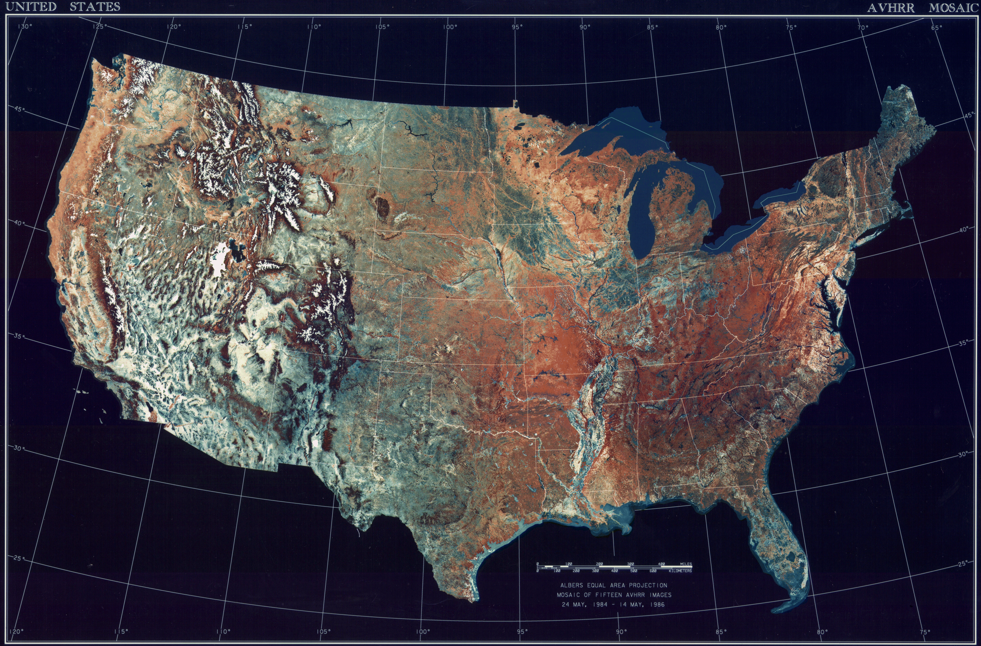
ملف:USATopographicalMap.jpg
حجم هذه المعاينة: 800 × 527 بكسل. الأبعاد الأخرى: 320 × 211 بكسل | 640 × 422 بكسل | 1٬024 × 674 بكسل | 1٬280 × 843 بكسل | 2٬560 × 1٬686 بكسل | 3٬199 × 2٬107 بكسل.
الملف الأصلي (3٬199 × 2٬107 بكسل حجم الملف: 11٫19 ميجابايت، نوع MIME: image/jpeg)
| هذا ملف من ويكيميديا كومنز. معلومات من صفحة وصفه مبينة في الأسفل. كومنز مستودع ملفات ميديا ذو رخصة حرة. |
ملخص
| الوصف |
Deutsch: Satellitenbild der 48 Zentralstaaten der Vereinigten Staaten.
|
| التاريخ | بين ٢٤ مايو ١٩٨٤ و ١٤ مايو ١٩٨٦ |
| المصدر | National Climactic Data Center/NOAA Satellite and Information Service |
| المؤلف | U.S. Dept. of Commerce/National Climactic Data Center/NOAA Satellite and Information Service |
ترخيص
تحتوي هذه الصُّورة مواداً أنتجت بواسطة الإدارة الوطنيَّة للمحيطات والغلاف الجوي في الولايات المتَّحدة الأمريكيَّة. أُنشئت هذه المواد مِن قبل مُوظَّفٍ خلال أدائه لواجباته الرَّسميَّة أي أنَّها عملٌ من أعمال الحكومة الاتحاديَّة للولايات المتَّحدة، ولذلك فهي في النِّطاق العامِّ.
|
تاريخ الملف
اضغط على زمن/تاريخ لرؤية الملف كما بدا في هذا الزمن.
| زمن/تاريخ | صورة مصغرة | الأبعاد | مستخدم | تعليق | |
|---|---|---|---|---|---|
| حالي | 08:06، 25 أكتوبر 2013 | | 3٬199 × 2٬107 (11٫19 ميجابايت) | McZusatz | compression (uploaded using chunked upload script) |
| 17:33، 4 مارس 2009 |  | 3٬199 × 2٬107 (450 كيلوبايت) | File Upload Bot (Magnus Manske) | ((BotMoveToCommons|en.wikipedia|year=((subst:CURRENTYEAR))|month=((subst:CURRENTMONTHNAME))|day=((subst:CURRENTDAY)))) ((Information |Description=((en|Topographical map of the United States)) |Source=Transferred from [http://en.wikipedia.org en.wikipedia |
استخدام الملف
الصفحتان التاليتان تستخدمان هذا الملف:
الاستخدام العالمي للملف
الويكيات الأخرى التالية تستخدم هذا الملف:
- الاستخدام في arz.wikipedia.org
- الاستخدام في ceb.wikipedia.org
- الاستخدام في de.wikipedia.org
- الاستخدام في dtp.wikipedia.org
- الاستخدام في el.wikipedia.org
- الاستخدام في en.wikipedia.org
- الاستخدام في es.wikipedia.org
- الاستخدام في fa.wikipedia.org
- الاستخدام في fr.wikipedia.org
- الاستخدام في fy.wikipedia.org
- الاستخدام في gu.wikipedia.org
- الاستخدام في he.wikipedia.org
- الاستخدام في ia.wikipedia.org
- الاستخدام في incubator.wikimedia.org
- الاستخدام في kn.wikipedia.org
- الاستخدام في la.wikipedia.org
- الاستخدام في lt.wikipedia.org
- الاستخدام في mnw.wikipedia.org
- الاستخدام في ms.wikipedia.org
- الاستخدام في my.wikipedia.org
- الاستخدام في pap.wikipedia.org
- الاستخدام في sq.wikipedia.org
- الاستخدام في sv.wikipedia.org
- الاستخدام في sw.wikipedia.org
- الاستخدام في ta.wikipedia.org
- الاستخدام في tcy.wikipedia.org
- الاستخدام في th.wikipedia.org
- الاستخدام في tl.wikipedia.org
- الاستخدام في uk.wikipedia.org
- الاستخدام في www.wikidata.org
- الاستخدام في yo.wikipedia.org
Text is available under the CC BY-SA 4.0 license; additional terms may apply.
Images, videos and audio are available under their respective licenses.
Cover photo is available under {{::mainImage.info.license.name || 'Unknown'}} license.
Cover photo is available under {{::mainImage.info.license.name || 'Unknown'}} license.
Credit:
(see original file).
