ملف:Tabaristan boundary.png
لا توجد دقة أعلى متوفرة.
Tabaristan_boundary.png (659 × 571 بكسل حجم الملف: 831 كيلوبايت، نوع MIME: image/png)
| هذا ملف من ويكيميديا كومنز. معلومات من صفحة وصفه مبينة في الأسفل. كومنز مستودع ملفات ميديا ذو رخصة حرة. |

|
هذه historical map الصورة / الصورتان باستعمال رسومات متجهية ملفات رسوميات شعاعية.
It is recommended to name the SVG file "Tabaristan boundary.svg" - then the template Vector version available (or Vva) does not need the new image name parameter.
|
ملخص
| الوصف |
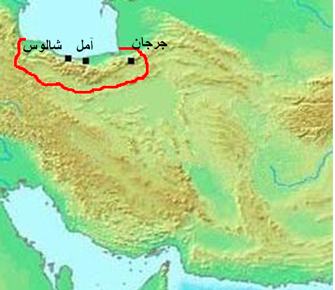
العربية: الحدود التقريبية لإقليم طبرستان القديم، بناءً على هذه الخريطة ووصف ياقوت الحموي في كتابه معجم البلدان للمنطقة.
English: Approximate boundary of Tabaristan region, based upon that map and Mu'jam Al-Buldan of Yaqut al-Hamawi description for the region. |
| التاريخ | for the latest version |
| المصدر | modified from Asia 100bc.jpg |
| المؤلف | Thomas A. Lessman (modified by aad_Dira) |
ترخيص
هذا الملفُّ مُرخَّص بموجب رخصة المشاع الإبداعي نسبة المُصنَّف إِلى مُؤَلِّفه - المشاركة بالمثل 3.0 العامة
- يحقُّ لك:
- مشاركة العمل – نسخ العمل وتوزيعه وبثُّه
- إعادة إنتاج العمل – تعديل العمل
- حسب الشروط التالية:
- نسب العمل إلى مُؤَلِّفه – يلزم نسب العمل إلى مُؤَلِّفه بشكل مناسب وتوفير رابط للرخصة وتحديد ما إذا أجريت تغييرات. بالإمكان القيام بذلك بأية طريقة معقولة، ولكن ليس بأية طريقة تشير إلى أن المرخِّص يوافقك على الاستعمال.
- الإلزام بترخيص المُشتقات بالمثل – إذا أعدت إنتاج المواد أو غيرت فيها، فيلزم أن تنشر مساهماتك المُشتقَّة عن الأصل تحت ترخيص الأصل نفسه أو تحت ترخيص مُتوافِقٍ معه.
تاريخ الملف
اضغط على زمن/تاريخ لرؤية الملف كما بدا في هذا الزمن.
| زمن/تاريخ | صورة مصغرة | الأبعاد | مستخدم | تعليق | |
|---|---|---|---|---|---|
| حالي | 21:22، 17 مارس 2011 | | 659 × 571 (831 كيلوبايت) | عباد ديرانية | تعزيز لون الحدود. |
| 20:39، 17 مارس 2011 |  | 659 × 571 (838 كيلوبايت) | عباد ديرانية | ((Information |Description =((ar|1=الحدود التقريبية لإقليم طبرستان القديم، بناءً على [http://www.nooor.com/media/3692/%D8%AE%D8%B1%D9%8A%D8%B7%D8%A9_%D8%B7%D8%A8%D8%B1%D8%B3%D8%AA%D8%A7%D9%86/ هذه الخر� |
استخدام الملف
الصفحتان التاليتان تستخدمان هذا الملف:
الاستخدام العالمي للملف
الويكيات الأخرى التالية تستخدم هذا الملف:
- الاستخدام في diq.wikipedia.org
Text is available under the CC BY-SA 4.0 license; additional terms may apply.
Images, videos and audio are available under their respective licenses.
Cover photo is available under {{::mainImage.info.license.name || 'Unknown'}} license.
Cover photo is available under {{::mainImage.info.license.name || 'Unknown'}} license.
Credit:
(see original file).
