ملف:Sivas districts.png
حجم هذه المعاينة: 776 × 600 بكسل. الأبعاد الأخرى: 311 × 240 بكسل | 621 × 480 بكسل | 994 × 768 بكسل | 1٬056 × 816 بكسل.
الملف الأصلي (1٬056 × 816 بكسل حجم الملف: 35 كيلوبايت، نوع MIME: image/png)
| هذا ملف من ويكيميديا كومنز. معلومات من صفحة وصفه مبينة في الأسفل. كومنز مستودع ملفات ميديا ذو رخصة حرة. |
ملخص
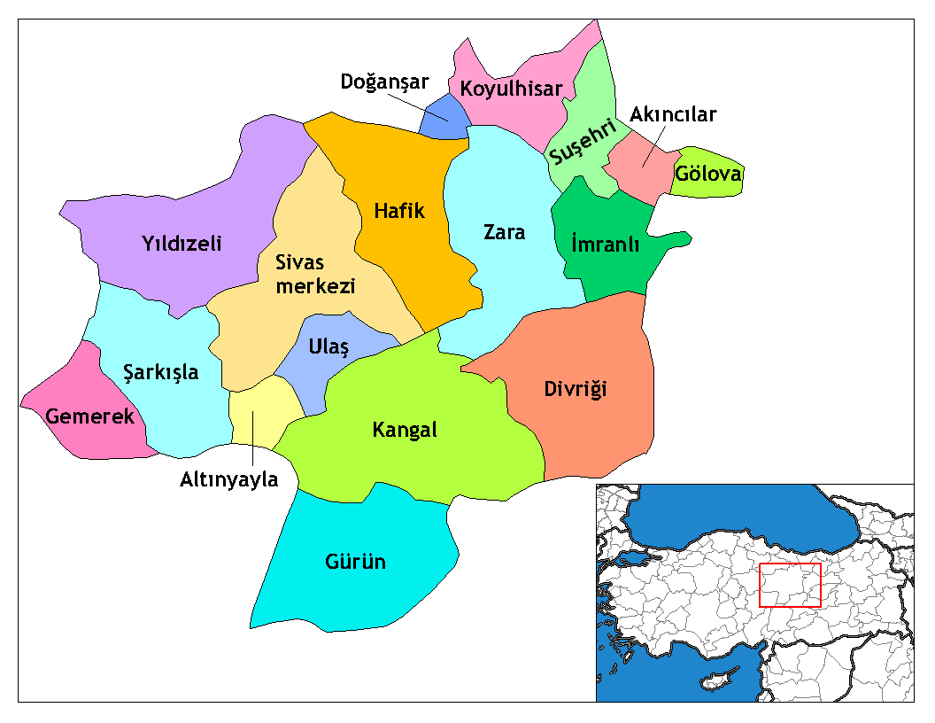
| الوصف | Map of the districts of Sivas province in Turkey. Created by Rarelibra 17:51, 4 December 2006 (UTC) for public domain use, using MapInfo Professional v8.5 and various mapping resources. Edited by One Homo Sapiens Corrected text where İ,Ş,ı,ğ,or ş occurs in name. Source: [statoids-com]. Increased font size and enhanced color differences among adjacent districts. |
| التاريخ | ٤ ديسمبر ٢٠٠٦ (تاريخ الرفع الأصيل) |
| المصدر | لم يتم توفير مصدر قابل للقراءة، العمل الشخصي مفترض (بناء على مطالبات حقوق الطبع والنشر). |
| المؤلف | لم يتم توفير مؤلف قابل للقراءة; يُفترَض Rarelibra (استنادا إلى مطالبات حقوق الطبع والنشر). |

|
هذه locator map الصورة / الصورتان باستعمال رسومات متجهية ملفات رسوميات شعاعية.
It is recommended to name the SVG file "Sivas districts.svg" - then the template Vector version available (or Vva) does not need the new image name parameter.
|
ترخيص
| أنا، مالِك حقوق تأليف ونشر هذا العمل، أجعله في النِّطاق العامِّ، يسري هذا في أرجاء العالم كلِّه. في بعض البلدان، قد يكون هذا التَّرخيص غيرَ مُمكنٍ قانونيَّاً، في هذه الحالة: أمنح الجميع حق استخدام هذا العمل لأي غرض دون أي شرط ما لم يفرض القانون شروطًا إضافية. |
تاريخ الملف
اضغط على زمن/تاريخ لرؤية الملف كما بدا في هذا الزمن.
| زمن/تاريخ | صورة مصغرة | الأبعاد | مستخدم | تعليق | |
|---|---|---|---|---|---|
| حالي | 02:09، 29 ديسمبر 2008 | | 1٬056 × 816 (35 كيلوبايت) | One Homo Sapiens | Corrected text where İ,Ş,ı,ğ,or ş occurs in name. Source: [statoids-com]. Increased font size and enhanced color differences among adjacent districts. |
| 17:51، 4 ديسمبر 2006 |  | 1٬056 × 816 (37 كيلوبايت) | Rarelibra | Map of the districts of Sivas province in Turkey. Created by ~~~~ for public domain use, using MapInfo Professional v8.5 and various mapping resources. |
استخدام الملف
الصفحتان التاليتان تستخدمان هذا الملف:
الاستخدام العالمي للملف
الويكيات الأخرى التالية تستخدم هذا الملف:
- الاستخدام في arz.wikipedia.org
- الاستخدام في ast.wikipedia.org
- الاستخدام في azb.wikipedia.org
- الاستخدام في ca.wikipedia.org
- الاستخدام في cs.wikipedia.org
- الاستخدام في de.wikipedia.org
- الاستخدام في diq.wikipedia.org
اعرض المزيد من الاستخدام العام لهذا الملف.
بيانات وصفية
Text is available under the CC BY-SA 4.0 license; additional terms may apply.
Images, videos and audio are available under their respective licenses.
Cover photo is available under {{::mainImage.info.license.name || 'Unknown'}} license.
Cover photo is available under {{::mainImage.info.license.name || 'Unknown'}} license.
Credit:
(see original file).
