For faster navigation, this Iframe is preloading the Wikiwand page for ملف:Italy map with regions numbered 2.svg.

ملف:Italy map with regions numbered 2.svg
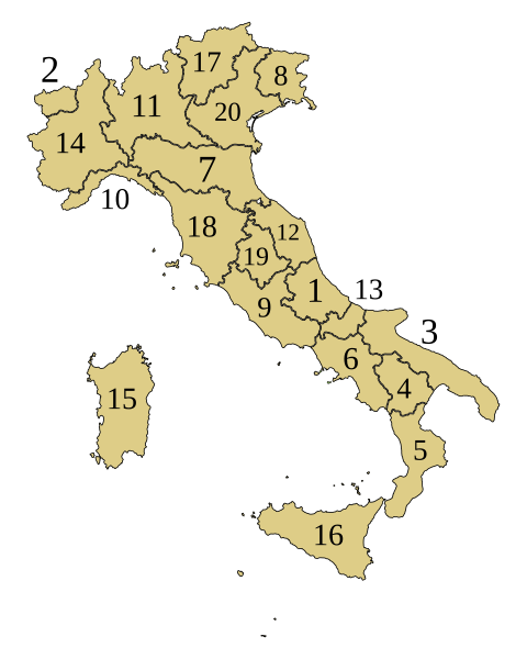
الملف الأصلي(ملف SVG، أبعاده 1٬200 × 1٬500 بكسل، حجم الملف: 639 كيلوبايت)

الوصف
Slovenščina: Italijanske dežele:
  1. Abruci (Abruzzo)
  2. Aosta (Valle d'Aosta) *
  3. Apulija (Puglia)
  4. Bazilikata (Basilicata)
  5. Kalabrija (Calabria)
  6. Kampanija (Campania)
  7. Emilija - Romanja (Emilia-Romagna)
  8. Furlanija - Julijska krajina (Friuli-Venezia Giulia)*
  9. Lacij (Lazio)
  10. Ligurija (Liguria)
  11. Lombardija (Lombardia)
  12. Marke (Marche)
  13. Molize (Molise)
  14. Pjemont (Piemonte)
  15. Sardinija (Sardegna) *
  16. Sicilija (Sicilia) *
  17. Trentinsko in Zgornje Poadižje ali Trentinsko-Južna Tirolska (Trentino-Alto Adige/Südtirol) *
  18. Toskana (Toscana)
  19. Umbrija (Umbria)
  20. Benečija (Veneto)
التاريخ
المصدر simplified Image:Languages spoken in Italy.svg
المؤلف ~~helix84
الترخيص
(إعادة استخدام هذا الملف)
Public domain أنا، مالِك حقوق تأليف ونشر هذا العمل، أجعله في النِّطاق العامِّ، يسري هذا في أرجاء العالم كلِّه.
في بعض البلدان، قد يكون هذا التَّرخيص غيرَ مُمكنٍ قانونيَّاً، في هذه الحالة:
أمنح الجميع حق استخدام هذا العمل لأي غرض دون أي شرط ما لم يفرض القانون شروطًا إضافية.
Public domain وضع -F l a n k e r-، وهو المؤلف، هذا العمل في النِّطاق العامِّ. يسري ذلك في كل أرجاء العالم.

في بعض البلدان، قد يكون هذا التَّرخيص غيرَ مُمكنٍ قانونيَّاً، في هذه الحالة:
يمنح F l a n k e r الجميع حق استخدام هذا العمل لأي غرض دون أي شرط ما لم يفرض القانون شروطًا إضافية.

إصدارات أخرى

الشروحات

أضف شرحاً من سطر واحد لما يُمثِّله هذا الملف

العناصر المصورة في هذا الملف

يُصوِّر

٥ أبريل 2007

تاريخ الملف

اضغط على زمن/تاريخ لرؤية الملف كما بدا في هذا الزمن.

زمن/تاريخصورة مصغرةالأبعادمستخدمتعليق
حالي00:07، 13 ديسمبر 2022تصغير للنسخة بتاريخ 00:07، 13 ديسمبر 20221٬200 × 1٬500 (639 كيلوبايت)Scip.numbers better visible. different color
12:45، 28 يوليو 2015تصغير للنسخة بتاريخ 12:45، 28 يوليو 20151٬200 × 1٬500 (639 كيلوبايت)CarnbyMolise
23:09، 5 أبريل 2007تصغير للنسخة بتاريخ 23:09، 5 أبريل 20071٬200 × 1٬500 (638 كيلوبايت)Helix84fixed
22:21، 5 أبريل 2007تصغير للنسخة بتاريخ 22:21، 5 أبريل 20071٬200 × 1٬500 (620 كيلوبايت)Helix84((Information |Description= |Source=simplified Image:Languages spoken in Italy.svg |Date=5.4.2007 |Author=~~helix84 |Permission=((PD-self))((PD-user|F l a n k e r)) |other_versions= * Image:Italy_map_with_regions.svg - regions w

استخدام الملف

الصفحة التالية تستخدم هذا الملف:

الاستخدام العالمي للملف

الويكيات الأخرى التالية تستخدم هذا الملف:

اعرض المزيد من الاستخدام العام لهذا الملف.

بيانات وصفية

{{bottomLinkPreText}} {{bottomLinkText}}
ملف:Italy map with regions numbered 2.svg
Listen to this article

This browser is not supported by Wikiwand :(
Wikiwand requires a browser with modern capabilities in order to provide you with the best reading experience.
Please download and use one of the following browsers:

This article was just edited, click to reload
This article has been deleted on Wikipedia (Why?)

Back to homepage

Please click Add in the dialog above
Please click Allow in the top-left corner,
then click Install Now in the dialog
Please click Open in the download dialog,
then click Install
Please click the "Downloads" icon in the Safari toolbar, open the first download in the list,
then click Install
{{::$root.activation.text}}

Install Wikiwand

Install on Chrome Install on Firefox
Don't forget to rate us

Tell your friends about Wikiwand!

Gmail Facebook Twitter Link

Enjoying Wikiwand?

Tell your friends and spread the love:
Share on Gmail Share on Facebook Share on Twitter Share on Buffer

Our magic isn't perfect

You can help our automatic cover photo selection by reporting an unsuitable photo.

This photo is visually disturbing This photo is not a good choice

Thank you for helping!


Your input will affect cover photo selection, along with input from other users.

X

Get ready for Wikiwand 2.0 🎉! the new version arrives on September 1st! Don't want to wait?