ملف:Greaterboston2.png
لا توجد دقة أعلى متوفرة.
Greaterboston2.png (500 × 500 بكسل حجم الملف: 68 كيلوبايت، نوع MIME: image/png)
| هذا ملف من ويكيميديا كومنز. معلومات من صفحة وصفه مبينة في الأسفل. كومنز مستودع ملفات ميديا ذو رخصة حرة. |
ملخص
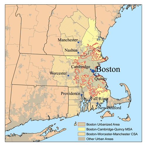
| الوصف | This is a map of the Greater Boston Metro area I made using U.S. Census Bureau data as of 2006. The light gray shading indicates urbanized areas with Greater Boston as defined by urbanized areas outlined in red. The Metropolitan Statistical Area is shown in yellow. The Combined Statistical Area includes the MSA plus those counties that are partially shaded. The Providence metro area was added to the Boston CSA in 2005. |
| التاريخ | ١٠ يناير ٢٠٠٧ (تاريخ الرفع الأصيل) |
| المصدر | لم يتم توفير مصدر قابل للقراءة، العمل الشخصي مفترض (بناء على مطالبات حقوق الطبع والنشر). |
| المؤلف | لم يتم توفير مؤلف قابل للقراءة; يُفترَض Kmusser (استنادا إلى مطالبات حقوق الطبع والنشر). |
ترخيص
أنا، صاحب حقوق التأليف والنشر لهذا العمل، أنشر هذا العمل تحت الرخصة التالية:
هذا الملف مُرخص تحت رخصة المشاع الإبداعي نسبة المصنف إلى مؤلفه - المشاركة على قدم المساواة 2.5 العامة.
- يحقُّ لك:
- مشاركة العمل – نسخ العمل وتوزيعه وبثُّه
- إعادة إنتاج العمل – تعديل العمل
- حسب الشروط التالية:
- نسب العمل إلى مُؤَلِّفه – يلزم نسب العمل إلى مُؤَلِّفه بشكل مناسب وتوفير رابط للرخصة وتحديد ما إذا أجريت تغييرات. بالإمكان القيام بذلك بأية طريقة معقولة، ولكن ليس بأية طريقة تشير إلى أن المرخِّص يوافقك على الاستعمال.
- الإلزام بترخيص المُشتقات بالمثل – إذا أعدت إنتاج المواد أو غيرت فيها، فيلزم أن تنشر مساهماتك المُشتقَّة عن الأصل تحت ترخيص الأصل نفسه أو تحت ترخيص مُتوافِقٍ معه.
تاريخ الملف
اضغط على زمن/تاريخ لرؤية الملف كما بدا في هذا الزمن.
| زمن/تاريخ | صورة مصغرة | الأبعاد | مستخدم | تعليق | |
|---|---|---|---|---|---|
| حالي | 22:14، 16 يناير 2007 | | 500 × 500 (68 كيلوبايت) | Kmusser | increased contrast |
| 17:22، 10 يناير 2007 |  | 500 × 500 (64 كيلوبايت) | Kmusser | == Summary == This is a map of the Greater Boston Metro area I made using U.S. Census Bureau data as of 2006. The light gray shading indicates urbanized areas with Greater Boston as defined by urb |
استخدام الملف
الصفحة التالية تستخدم هذا الملف:
الاستخدام العالمي للملف
الويكيات الأخرى التالية تستخدم هذا الملف:
- الاستخدام في ast.wikipedia.org
- الاستخدام في azb.wikipedia.org
- الاستخدام في ca.wikipedia.org
- الاستخدام في de.wikipedia.org
- الاستخدام في en.wikipedia.org
- الاستخدام في eo.wikipedia.org
- الاستخدام في es.wikipedia.org
- الاستخدام في fa.wikipedia.org
- الاستخدام في fr.wikipedia.org
- الاستخدام في gl.wikipedia.org
- الاستخدام في it.wikivoyage.org
- الاستخدام في ko.wikipedia.org
- الاستخدام في pl.wikipedia.org
- الاستخدام في ru.wikipedia.org
- الاستخدام في simple.wikipedia.org
- الاستخدام في sv.wikipedia.org
- الاستخدام في ta.wikipedia.org
- الاستخدام في uk.wikipedia.org
- الاستخدام في ur.wikipedia.org
- الاستخدام في vi.wikipedia.org
- الاستخدام في www.wikidata.org
- الاستخدام في zh.wikipedia.org
Text is available under the CC BY-SA 4.0 license; additional terms may apply.
Images, videos and audio are available under their respective licenses.
Cover photo is available under {{::mainImage.info.license.name || 'Unknown'}} license.
Cover photo is available under {{::mainImage.info.license.name || 'Unknown'}} license.
Credit:
(see original file).
