سيليزيا
| سيليزيا | ||
|---|---|---|
 |
||
|
||
 |
||
 |
||
| الإحداثيات | 51°06′13″N 17°02′23″E / 51.1035°N 17.0396°E | |
| تقسيم إداري | ||
| البلد | ||
| العاصمة | فروتسواف | |
| خصائص جغرافية | ||
| المساحة | 40000 كيلومتر مربع | |
| معلومات أخرى | ||
| منطقة زمنية | توقيت وسط أوروبا | |
| رمز جيونيمز | 3066138 | |
| تعديل مصدري - تعديل | ||

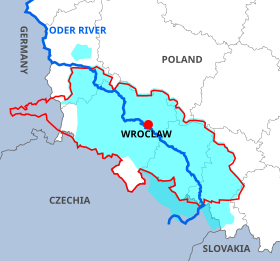
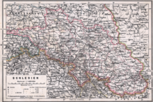
سيليزيا (بالبولندية: Śląsk، بالألمانية: Schlesien، بالتشيكية: Slezsko) منطقة تاريخية في أوروبا الوسطى.[2][3][4] تغطي الأجزاء الجنوبية الغربية من بولندا وبعض أجزاء ألمانيا والتشيك. تقع على جبال السوديت ويخترقها نهر الأودر. أكبر مدنها هي مدينة فروتسواف في بولندا. وتضم سيليزيا السفلى وسيليزيا العليا.[5]
كانت في البداية تابعة لبولندا حتى عام 1163 حين أخذتها الإمبراطورية الرومانية المقدسة وأصبحت إقطاعية ثم أصبحت بعد ذلك دوقية تحت حكم ملك النمسا إلى أن فقدتها في حرب السنوات السبع ضد بروسيا، وأصبحت ألمانية عندما تمت الوحدة الألمانية عام 1871، ثم إندلعت الحرب العالمية الثانية التي انهزمت فيها ألمانيا وذهبت سيليسيا إلى بولندا التي استعادتها بعد 80 عام تقريبا. أهم المعارك التي حدثت فيها وأشهرها كانت معركة حقل ليغنيتسا والتي جرت يوم 9 أبريل 1241 في إطار الفتوحات المغولية حيث أباد الجيش المغولي قوة مشتركة من البولنديين والألمان من النظام التيوتوني وغيرهم.
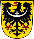
أعلام
[عدل]اقرأ أيضاً
[عدل]مراجع
[عدل]- ^ "صفحة سيليزيا في GeoNames ID". GeoNames ID. اطلع عليه بتاريخ 2024-07-19.
- ^ "Cadmium: World Refinery Production, By Country". Indexmundi.com. 18 مايو 2012. مؤرشف من الأصل في 2016-03-03. اطلع عليه بتاريخ 2013-11-20.
- ^ "Copper: World Smelter Production, By Country". Indexmundi.com. 28 يوليو 2011. مؤرشف من الأصل في 2017-12-11. اطلع عليه بتاريخ 2013-11-20.
- ^ "Silesia". Random House Webster's Unabridged Dictionary. نسخة محفوظة 10 يوليو 2018 على موقع واي باك مشين.
- ^ Hunt Tooley, T (1997). National Identity and Weimar Germany: Upper Silesia and the Eastern Border, 1918–1922, University of Nebraska Press, p.17.
| في كومنز صور وملفات عن: سيليزيا |
مناطق ومقاطعات بروسيا (1525–1947) | |
|---|---|
| قبل عام 1701 | دوقية بروسيا · مرغريفية براندنبورغ · كليفي / مارك / رايفنزبورغ (1614) · بوميرانيا / مندن / هالبرشتات (1648) · ونبورغ وبوتوف / دراهايم (1657) · ماغديبرغ (1680) · المستعمرات (ساحل الذهب البروسي · أرغوين · جزيرة السرطان · تورتولا) |
| بعد عام 1701 | نيوشاتل (1707) · العملات (1713) · مندن-رايفنزبورغ (1719) · بوميرانيا الغربية (1720, 1815) · سيليزيا / غلاتز (1742) · شرق فريزيا (1744) · مقاطعة بروسيا الشرقية / بروسيا الغربية (1772-73) · بروسيا الجنوبية (1793) · بروسيا الشرقية الجديدة / سيليزيا الجديدة (1795) |
| بعد مؤتمر فيينا (1814–15) | براندنبورغ · بوميرانيا · دوقية بوزن الكبرى1 · سكسونيا · سيليزيا · وستفاليا · مقاطعة الراين2 (1822) · مقاطعة بروسيا (1824–78) · هوهنتسولرن (1850) · شليسفيغ-هولشتاين / هانوفر / هيسن-ناسو (1866–68) |
| إعادة توزيع الأراضي بعد عام 1918 | السفلى / سيليزيا العليا (1919) · برلين الكبرى (1920) · بوزن-بروسيا الغربية (1922) ·
هاله-مرسيبورغ / ماغديبرغ / هيس الإنتخابية / ناسو (1944) |
1 أصبحت محافظة بوزن في عام 1848. 2 من دوقية الراين السفلى الكبرى ومقاطعة يوليخ-كليفي-بيرغ. | |
- بوابة ألمانيا
- بوابة الإمبراطورية الرومانية المقدسة
- بوابة الاتحاد الأوروبي
- بوابة التشيك
- بوابة بولندا
- بوابة جغرافيا
| دولية | |
|---|---|
| وطنية | |
| أخرى | |
Text is available under the CC BY-SA 4.0 license; additional terms may apply.
Images, videos and audio are available under their respective licenses.

