تورميس
هذه المقالة يتيمة إذ تصل إليها مقالات أخرى قليلة جدًا. فضلًا، ساعد بإضافة وصلة إليها في مقالات متعلقة بها. (أغسطس 2024)
| تورميس | |
|---|---|
 | |
 |
|
| المنطقة | |
| البلد | |
| الخصائص | |
| الطول | 284 كيلومتر[1] |
| المصب | دورو |
| مساحة الحوض | 7109 كيلومتر مربع[2] |
| تعديل مصدري - تعديل | |
نهر تورميس هو نهر إسباني يقع في مقاطعتي شلمنقة وأبلة والرافد الأيسر لنهر دويرة .
الجغرافيا
[عدل]ينبع نهر تورميس من برادو تورميجون ، في سلسلة جبال سييرا دي غريدوس ، في نافاريدوندا دي غريدوس ، في مقاطعة أبلة. يبلغ طوله 284 كيلومتر، ويعبر الأخيرة بالإضافة إلى مقاطعة شلمنقة ، ثم ينفتح على الدويرة، عند فيلارينو دي لوس آيريس ، في مكان يسمى محليًا أمباساجواس، على الحدود بين إسبانيا والبرتغال. وبالتالي فإن نهر تورميس هو أحد روافد نهر الدويرة على الضفة اليسرى.[3]
معرض الصور
[عدل]-

نهر تورميس في نافاموريسكا في قرية إل لوسار (الضفة اليسرى) وفي فاليهوندو في قرية سان لورينزو دي تورميس (الضفة اليمنى). -
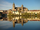
تورميس أمام كاتدرائية سالامانكا الجديدة . -
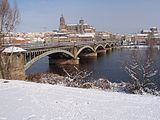
جسر إنريكي إستيفان الذي يمتد على نهر تورميس في سالامانكا .


انظر أيضا
[عدل]
خريطة لجميع الإحداثيات من جوجل
خريطة لجميع الإحداثيات من بينغ
تصدير جميع الإحداثيات من كيه إم إل
تصدير جميع الإحداثيات من جيو ر س س
خريطة لجميع الإحداثيات الميكرو منسقة
بيانات من إطار توصيف الموارد
مراجع
[عدل]- ^ https://www.enciclopedia.cat/EC-GEC-0066516.xml.
((استشهاد ويب)):|url=بحاجة لعنوان (مساعدة) والوسيط|title=غير موجود أو فارغ (من ويكي بيانات) (مساعدة) - ^ http://www.chduero.es/Inicio/Organismo/LacuencadelDuero/Caracter%C3%ADsticasgenerales/tabid/86/Default.aspx.
((استشهاد ويب)):|url=بحاجة لعنوان (مساعدة) والوسيط|title=غير موجود أو فارغ (من ويكي بيانات) (مساعدة) - ^ (بالإسبانية) Embalse: Santa Teresa, Embalses.net, estado de los embalses y pantanos de España. Consulté le 21 mars 2009. نسخة محفوظة 2024-04-07 على موقع واي باك مشين.
| تورميس في المشاريع الشقيقة: | |
| |
Text is available under the CC BY-SA 4.0 license; additional terms may apply.
Images, videos and audio are available under their respective licenses.
Cover photo is available under {{::mainImage.info.license.name || 'Unknown'}} license.
Cover photo is available under {{::mainImage.info.license.name || 'Unknown'}} license.
Credit:
(see original file).
