برغ (النرويج)
| برغ | |||
|---|---|---|---|
 |
|||
|
|||
 |
|||
 |
|||
| الإحداثيات | 69°28′00″N 17°23′52″E / 69.466666666667°N 17.397777777778°E [1] | ||
| تاريخ التأسيس | 1837 | ||
| تقسيم إداري | |||
| البلد | |||
| التقسيم الأعلى | ترومس | ||
| تاريخ الإلغاء | 31 ديسمبر 2019 | ||
| خصائص جغرافية | |||
| المساحة | 293.8868887942608 كيلومتر مربع (18 يناير 2018)[3] | ||
| عدد السكان | |||
| عدد السكان | 915 (1 يناير 2016)[4] | ||
| الكثافة السكانية | 3.113 نسمة/كم2 | ||
| عدد الأسر | 419 (2018)[5] 379 (2018)[5] 19 (2018)[5] 10 (2018)[5] 5 (2018)[5] 6 (2018)[5] |
||
| معلومات أخرى | |||
| منطقة زمنية | ت ع م+01:00 | ||
| رمز جيونيمز | 6453317 | ||
| الموقع الرسمي | الموقع الرسمي | ||
| تعديل مصدري - تعديل | |||
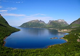
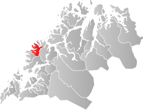
برغ (بالنرويجية: Berg) هي بلدية في مقاطعة ترومس، النرويج. المركز الإداري للبلدية هي قرية سكالاند. من بين القرى الأخرى في البلدية فينساتر، وميفيوردفار، وسينياهوبن.
المناخ
[عدل]يظهر الجدول التالي التغييرات المناخية على مدار السنة لبرغ:
| البيانات المناخية لـبرغ | |||||||||||||
|---|---|---|---|---|---|---|---|---|---|---|---|---|---|
| الشهر | يناير | فبراير | مارس | أبريل | مايو | يونيو | يوليو | أغسطس | سبتمبر | أكتوبر | نوفمبر | ديسمبر | المعدل السنوي |
| المتوسط اليومي °م (°ف) | −2.5 (27.5) |
−2.5 (27.5) |
−1.4 (29.5) |
1.2 (34.2) |
5.3 (41.5) |
8.8 (47.8) |
11.3 (52.3) |
11.1 (52.0) |
7.8 (46.0) |
4.1 (39.4) |
0.6 (33.1) |
−1.6 (29.1) |
3.5 (38.3) |
| الهطول مم (إنش) | 109 (4.3) |
94 (3.7) |
88 (3.5) |
77 (3.0) |
55 (2.2) |
67 (2.6) |
77 (3.0) |
91 (3.6) |
115 (4.5) |
152 (6.0) |
129 (5.1) |
131 (5.2) |
1٬185 (46.7) |
| المصدر: Norwegian Meteorological Institute[6] | |||||||||||||
مراجع
[عدل]- ^ "صفحة برغ (النرويج) في خريطة الشارع المفتوحة". OpenStreetMap. اطلع عليه بتاريخ 2024-09-15.
- ^ "صفحة برغ (النرويج) في GeoNames ID". GeoNames ID. اطلع عليه بتاريخ 2024-09-15.
- ^ "Arealstatistikk for Norge" (بالنرويجية البوكمول). Statens kartverk. 27 Feb 2018.
- ^ "Befolkning, 1. januar 2016" (بالنرويجية البوكمول). Statistisk sentralbyrå.
- ^ Statistisk sentralbyrå (7 May 2019), 11508: Bygningstype. Husholdninger (K) (B) 2015 - 2018 (بالنرويجية البوكمول والإنجليزية), Statistisk sentralbyrå, QID:Q88504419
- ^ "eKlima Web Portal". Norwegian Meteorological Institute. مؤرشف من الأصل في 2004-06-14.
| في كومنز صور وملفات عن: برغ |
Text is available under the CC BY-SA 4.0 license; additional terms may apply.
Images, videos and audio are available under their respective licenses.


