Timor Oriental
| Iste articlo ye en proceso de cambio enta la ortografía oficial de Biquipedia (la Ortografía de l'aragonés de l'Academia Aragonesa d'a Luenga). Puez aduyar a completar este proceso revisando l'articlo, fendo-ie los cambios ortograficos necesarios y sacando dimpués ista plantilla. |
| Republica Democratica de Timor Oriental Repúblika Demokrátika Timor Lorosa'e República Democrática de Timor-Leste | |||||
| |||||
| Lema nacional: Honra, Pátria e Povo | |||||
| Himno nacional: Pátria | |||||
 | |||||
| Capital • Población |
Dili 328.666 (2019) | ||||
| Mayor ciudat | |||||
| Idiomas oficials | Tetun y portugués | ||||
| Forma de gubierno President
Primer ministro |
Republica José Ramos-Horta Taur Matan Ruak | ||||
| Independencia De Portugal - Declarada - Reconoixida |
28 de noviembre de 1975 20 de mayo de 2002 | ||||
| Superficie • Total |
Posición 154º 15.007 km² | ||||
| Población • Total • Densidat |
Posición 153º 1.280.743 (2019) 68 hab/km² | ||||
| PIB (PPA) • Total ([[]]) • PIB per capita |
Posición º | ||||
| Moneda | Dólar estausunidense ($ USD) | ||||
| Chentilicio | Timorés/a | ||||
| Zona horaria | UTC+9 | ||||
| Dominio d'Internet | .tl | ||||
| Codigo telefonico | +670
| ||||
| Prefixo radiofonico | | ||||
| Codigo ISO | 626 / TL / TLS | ||||
| Miembro de: CPLP, ONU | |||||
Timor Oriental u Timor Este ye un país d'o sudeste d'Asia formato por a metat oriental d'a isla de Timor, as islas vicinas d'Ataúro y Jaco, y tamién Ocusi-Ambeno, un enclau politico de Timor Oriental situato en o canto ueste d'a isla, rodiato por Timor Occidental que fa parte d'Indonesia. A capital d'o país ye Dili.
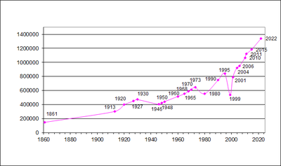
A suya población ye de 1.019.252 habitants (2004) en una superficie de 15.007 km², con una densidat de población de 68 hab/km².
Estió una colonia portuguesa dica 1975, cuan fue invadito per Indonesia. Romanió oficialment como territorio portugués per descolonizar dica 1999. Fue considerato per Indonesia como a suya provincia numero 27. O 80% d'o pueblo timorés esleyió a independencia en referendo organizato per as Nacions Unidas.
A luenga mes charrata en Timor Oriental ye o tetun, que ye oficial chunto con o portugués.
División administrativa
[editar | modificar o codigo]Timor Oriental ye subdividito en 13 districtos administrativos:
- Aileu
- Ainaro
- Baucau
- Bobonaro
- Cova-Lima
- Dili
- Ermera
- Lautém
- Liquiçá
- Manatuto
- Manufahi
- Oecusi-Ambeno
- Viqueque
Cheografía
[editar | modificar o codigo]Timor Oriental poseye un territorio de 18 mil km², ocupando a parti oriental d'a isla de Timor. O país ye a-saber-lo montanyoso y ha un clima tropical. Con plevias d'os rechímens d'os monzons, concara alurtes de tierras y frecuents inundacions. O país poseye 800 mil habitants.
Demografía
[editar | modificar o codigo]
| Estaus d'Asia |
|
Afganistán | Arabia Saudita | Armenia1 | Azerbaichán1 | Bahrein | Bangladesh | Birmania | Bután | Brunei | Cambocha | Cazaquistán1 | Cischordania2 | Corea d'o Norte | Corea d'o Sud | Chapón | Cheorchia1 | Republica Popular de China | Republica de China (Taiwan) | Chipre1 | Chordania | Echipto | Emiratos Arabes Unius | Francha de Gaza2 | Filipinas | India | Indonesia | Irán | Iraq | Israel | Kirguizistán | Kuwait | Laos | Liban | Malaisia | Maldivas | Mongolia | Nepal | Omán | Pakistán | Qatar | Rusia1 | Singapur | Sri Lanka | Siria | Tachiquistán | Tailandia | Timor Oriental | Turquía1 | Turkmenistán | Uzbekistán | Yemen | Vietnam |
| Dependencias: Akrotiri y Dhekelia | Hong Kong | Islas Cocos | Isla de Nadal | Macau | Territorio Britanico de l'Ocián Indico |
| 1 Perteneix a Europa por razons culturals y historicas, pero cheograficament ye en Asia. 2 Territorios controlaus por Israel y gubernaus por l'Autoridat Palestina. |
Text is available under the CC BY-SA 4.0 license; additional terms may apply.
Images, videos and audio are available under their respective licenses.


