For faster navigation, this Iframe is preloading the Wikiwand page for Imachen:Chile location map.svg.

Imachen:Chile location map.svg
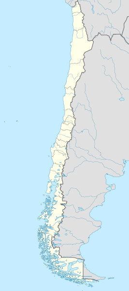
Fichero orichinal(fichero SVG, nominalment 1183 × 2658 píxels, grandaria: 925 kB)

Iste fichero ye de Wikimedia Commons y pueden emplegar-lo atros prochectos. Debaixo s'amuestra a descripción d'a suya pachina de descripción.

Resumen

Descripción
Deutsch: Positionskarte von Chile

Quadratische Plattkarte, N-S-Streckung 115 %. Geographische Begrenzung der Karte:

  • N: 17.4° S
  • S: 56.5° S
  • W: 81.5° W
  • O: 61.5° W
English: Location map of Chile

Equirectangular projection, N/S stretching 115 %. Geographic limits of the map:

  • N: 17.4° S
  • S: 56.5° S
  • W: 81.5° W
  • E: 61.5° W
Español: Mapa de localización de Chile

Proyección Equirectangular, N/S con una extensión de 115 %. Límites geográficos del mapa:

  • N: 17.4° S
  • S: 56.5° S
  • O: 81.5° O
  • E: 61.5° O
Calendata
Fuent

own work, using

  • United States National Imagery and Mapping Agency data
  • World Data Base II data
Autor NordNordWest
Atras versions

Derivative works of this file:

Kartenwerkstatt
Este mapa se ha hecho o mejorado en el Kartenwerkstatt (taller cartográfico) alemán. También puede proponer mapas para mejorar.

Licenciando

Yo, titular d'os dreitos d'autor d'ista obra, la publico en os termins d'as siguients licencias:
GNU head Se gosa premetir a copia, a destribución y a modificación d'iste decumento baixo d'os termins d'a licencia de decumentación libre GNU, Versión 1.2 u qualsiquier altra versión posteriorment expublicata por a Free Software Foundation; sin de seccions invariaderas (Unvariant Sections), textos de portalada (Front-Cover Texts), ni textos de contraportalada (Back-Cover Texts). S'enclui una copia d'ista licencia en anglés en l'articlo GNU Free Documentation License".
w:an:Creative Commons
atribución d'autoría compartir igual
Iste fichero se troba baixo a licencia Creative Commons Chenerica d'Atribución/Compartir-Igual 3.0.
Ye libre:
  • de compartir – de copiar, distribuir y transmitir o treballo
  • de remezclar – d'adaptar o treballo
Baixo as siguients condicions:
  • atribución d'autoría – Ha d'atribuir l'autoría d'o treballo d'a traza especificada por l'autor u persona que l'haiga licenciau (pero no pas de traza que suchiera que l'autor/os autors refirma(n) u refirma(n) l'uso que faigas d'o treballo).
  • compartir igual – En caso d'alterar, transformar u enamplar iste treballo, habrá de distribuir o treballo resultant solament baixo a mesma licencia u beluna equivalent.
Vusté puet utilizar a licencia que s'estime mas.

Leyendas

Añade una explicación corta acerca de lo que representa este archivo
Map of Chile

Elementos representados en este archivo

representa a espanyol

creador espanyol

Algún valor sin elemento de Wikidata

20 may 2008

tipo de archivo espanyol

image/svg+xml

9bc19cbea805182328e6b94da3b7814d41ba401d

método de determinación espanyol: SHA-1 espanyol

947 224 byte

altura espanyol

2658 píxel

ancho espanyol

1183 píxel

Historial d'o fichero

Punche en una calendata/hora ta veyer o fichero como amaneixeba por ixas envueltas.

(zagueras | primeras) Veyer (10 más recients | ) (10 | 20 | 50 | 100 | 250 | 500)
Calendata/HoraMiniaturaDimensionsUsuarioComentario
actual22:46 15 ago 2023Miniatura d'a versión de 22:46 15 ago 20231183 × 2658 (925 kB)JanitoalevicFixed Aysén & Magallanes and Chilean Antarctica Regions border.
22:54 5 set 2018Miniatura d'a versión de 22:54 5 set 20181183 × 2658 (925 kB)JanitoalevicÑuble Region
20:30 3 avi 2017Miniatura d'a versión de 20:30 3 avi 20171183 × 2658 (921 kB)Janitoaleviccolor error.
20:28 3 avi 2017Miniatura d'a versión de 20:28 3 avi 20171183 × 2658 (921 kB)JanitoalevicFixed Argentina's Lake Nahuel Huapi
20:25 3 avi 2017Miniatura d'a versión de 20:25 3 avi 20171183 × 2658 (920 kB)Janitoalevic.
21:50 2 avi 2017Miniatura d'a versión de 21:50 2 avi 20171183 × 2658 (920 kB)JanitoalevicFixed Argentina-Bolivia border
21:46 2 avi 2017Miniatura d'a versión de 21:46 2 avi 20171183 × 2658 (920 kB)Janitoalevic.
00:42 30 ago 2017Miniatura d'a versión de 00:42 30 ago 20171183 × 2658 (919 kB)JanitoalevicFixed size
23:30 20 ago 2017Miniatura d'a versión de 23:30 20 ago 20171262 × 2835 (910 kB)JanitoalevicRemoved Ñuble Region (Will be fully implemented in 2018)
01:00 20 ago 2017Miniatura d'a versión de 01:00 20 ago 20171262 × 2835 (914 kB)JanitoalevicAdded Ñuble Region & more precise borders
(zagueras | primeras) Veyer (10 más recients | ) (10 | 20 | 50 | 100 | 250 | 500)

Uso d'o fichero

Uso de fichers globals

Metadatos

{{bottomLinkPreText}} {{bottomLinkText}}
Imachen:Chile location map.svg
Listen to this article

This browser is not supported by Wikiwand :(
Wikiwand requires a browser with modern capabilities in order to provide you with the best reading experience.
Please download and use one of the following browsers:

This article was just edited, click to reload
This article has been deleted on Wikipedia (Why?)

Back to homepage

Please click Add in the dialog above
Please click Allow in the top-left corner,
then click Install Now in the dialog
Please click Open in the download dialog,
then click Install
Please click the "Downloads" icon in the Safari toolbar, open the first download in the list,
then click Install
{{::$root.activation.text}}

Install Wikiwand

Install on Chrome Install on Firefox
Don't forget to rate us

Tell your friends about Wikiwand!

Gmail Facebook Twitter Link

Enjoying Wikiwand?

Tell your friends and spread the love:
Share on Gmail Share on Facebook Share on Twitter Share on Buffer

Our magic isn't perfect

You can help our automatic cover photo selection by reporting an unsuitable photo.

This photo is visually disturbing This photo is not a good choice

Thank you for helping!


Your input will affect cover photo selection, along with input from other users.

X

Get ready for Wikiwand 2.0 🎉! the new version arrives on September 1st! Don't want to wait?