Napf
| Dä Artikel behandlet en Bärg i de Schwiz. Witeri Bedütige findt me under Napf. |
| Napf | ||
|---|---|---|
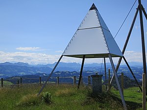
 dr Triangulazionspunkt ufem Napf vo 1860 | ||
| Hechi | 1'408 m ü. M. | |
| Lag | Kanton Bärn, Schwiz | |
| Gebirg | Napfbärgland | |
| Geografischi Lag | 638129 / 206023 | |
|
| ||
Dr Napf isch dr höggst Bärg im Napfbärgland in dr Schwiz.
Der Gupf isch uf 1'408 m ü. M. Es het es Bärgrestorant druff, wo uf em Gebiet vo dr Gmäind Trueb lyt. E chli im Norde vom Gipfel isch d Gränze zwüsche de Kantöön Bärn und Luzärn.
Dr Napf isch e Däil vom ene hooche Bärgkamm, wo vo Weschte gägen Oschte lauft und vom Farnli-Esel über e Höchänzi und dr Napf bis zum Hängst goot. D Abhäng vom Napf gege Norde und Süüde si seer stotzig und dicht bewaldet mit Danne und Bueche. D Kwelle vo dr Luthere und vo dr Änziwiggere si doo mit de andere Bech, wo zum Iizugsgebiet vo dr Wiggere ghööre. D Bärgbech fliesse dur dief ygcherbti Dääler gege Norde. Am Südhang vom Napf het d Trueb iiren Ursprung, wo denn dur e Fankhuusgraabe zur Ilfis abefliesst, eme rächte Nääbefluss vo dr Ämme.
Chly wyter im Oschte foot imene andere Daal der Goldbach a, wo en Kwellbach isch vo der grosse Fontanne; die goot zu der chlyne Ämme abe.
Dr Bärg bestoot us Gstäischichte, wo zur Zit vo dr Oobere Süesswassermolasse vo mächtige Flüss us den Alpe am nördligen Alperand abglaageret worde si. Die Flüss häi lange Ziit vil Gröll mit sich gfüert, und dr Napf isch dorum zur Hauptsach us Nagelflue ufbaut, eme Konglomerat us abgrundete Gstäiblöck, wo underschidlig grooss si und mit eme Bindemiddel (Chalch, Sand und Doon) zum ene zämmehängende Gstäi verfestigt si. Zwüsche de Nagelflueschichte het s fiinchörnigi Sandstäi- und Mergelschichte.
Usgangspünkt für Wandrige uf e Napfgipfel si d Mettlenalp (1'052 m ü. M.) im Süde und Luthere (778 m ü. M.), s Luthere Bad (875 m ü. M.) und d Wiggerehütte (Gmäind Hergiswil bi Willisau) im Norde vom Bärg. Über e Napf füere die bäide Wanderrute Nr. 3 Alpepanorama-Wääg (Etappe 15 Napf–Lüderenalp) und Nr. 65 Gränzpfad Napfbärgland vo SchweizMobil.
Bilder
-
s Gipfelchrüz uf em Napf
-
s Bärghotel Napf
-
d Uussicht vom Napf zu de Bärner Alpe
-
Nagelflue
Weblingg
- Wandervorschleeg uf luthern.ch (Version im Webarchiv vom 15. November 2011)
- Wandervorschleeg Lutherdal uf luthern-bad.ch
- Wanderland Schwiz: Nr. 3 Alpepanorame-Wääg uf schweizmobil.ch
- Wanderland Schwiz: Nr. 65 Gränzpfad Napfbergland uf schweizmobil.ch
- Grenzpfad Napfbergland uf grenzpfad.ch
| Dä Artikel basiert uff ere fräie Übersetzig vum Artikel „Napf_(Berg)“ vu de dütsche Wikipedia. E Liste vu de Autore un Versione isch do z finde. |
Text is available under the CC BY-SA 4.0 license; additional terms may apply.
Images, videos and audio are available under their respective licenses.


